
Surveying & Mapping
- Home
- Services
Why Use Drones For Topographic Mapping And Surveying?
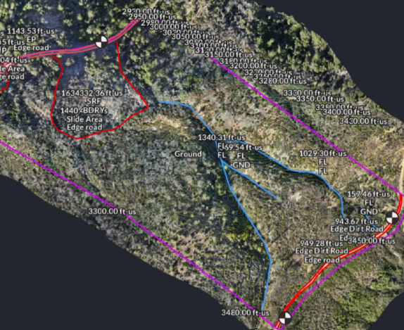
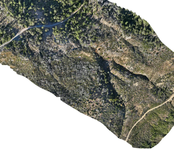
Creating a topographic map is often labor intensive and time consuming using traditional survey methods alone. However drones can efficiently collect data over large areas of land to create detailed and visual maps for better planning and drafting. Using drones for mapping and surveying offers several significant advantages compared to traditional survey methods alone.
Time-Saving
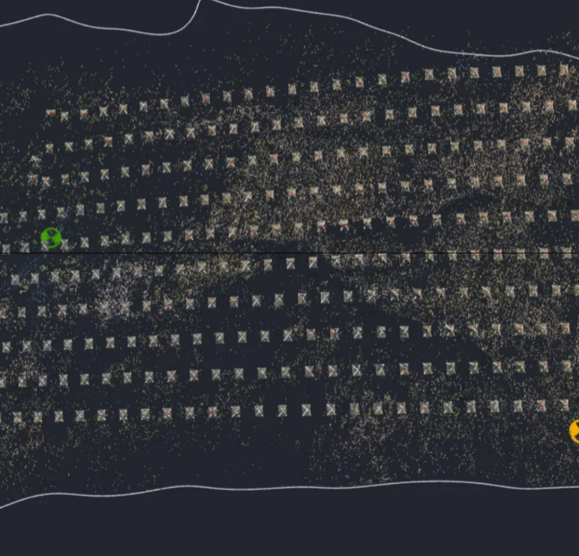
As the old saying goes, “time is money”, and that certainly holds true for construction projects. Drones significantly reduce the time required for data collection. Traditional survey methods often necessitate extensive on-site labor and can be very time-consuming especially in difficult terrain. In contrast, RTK drones can cover large areas swiftly, providing survey grade data within a fraction of the time. Drones can also capture every square inch of a project or job site, reducing the chances of missing important data due to human error.
Cost-Effective And Safety
Drones can help save costs in various ways. The large amounts of data drones can collect using relatively little time and manpower results in lower project costs. Drones can access challenging terrains that might require expensive equipment or extensive safety measures for traditional survey methods. Drone data is quickly processed into multiple files that can assist in drafting and analysis as well. For instance you may want the orthophoto on to quickly pick utility lids, or you may want to look at an overall elevation relief map. This makes drone surveys more affordable and accessible than ever before.
Integration With Industry Products
It’s no secret that drones have become an essential tool for any land surveyor. Drones equipped with advanced cameras and sensors capture high- resolution imagery and precise geospatial data. This ever improving technology allows for the creation of detailed and accurate maps, models, and surveys, often with better quality and higher resolution than traditional methods. This ensures that projects based on drone data are more reliable by reducing the chance for human errors, and effective by covering the project site completely.
Integration With Industry Products
Drones collect valuable data, while specialized photogrammetry software processes it in formats compatible with various applications used in surveying, mapping, and engineering. The seamless integration of drone technology with industry- standard programs like AutoCAD, has revolutionized the surveying and engineering fields. This integration enhances the workflow, allowing for faster analysis, decision-making, and project execution. Additionally, drone-generated data can be easily shared and collaborated on, further streamlining operations and improving productivity.
Embracing drone technology for mapping and surveying isn’t just a futuristic trend-it’s a practical solution that enhances efficiency, reduces costs, and produces superior results. Explore how drones can elevate your projects today. Here are some key outputs produced from drone data.
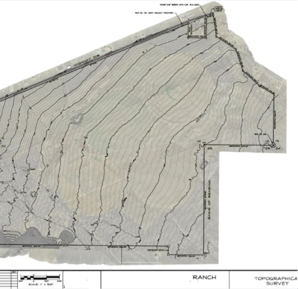
2D And 3D Maps
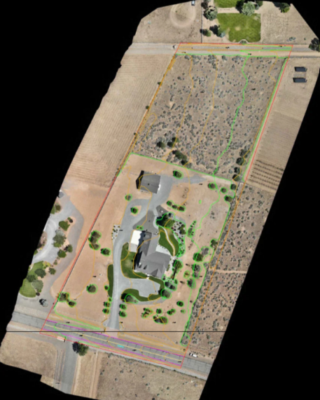
- Orthomosaics: High-resolution, geometrically corrected images that provide an accurate representation of the Earth’s surface.
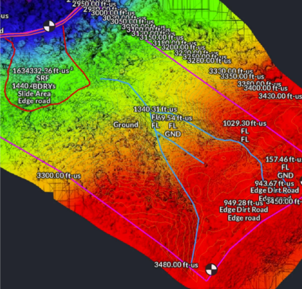
- Digital Surface Models (DSMs): Representations of the Earth’s surface, including all objects on it, such as buildings and vegetation.
- Digital Terrain Models (DTMs): Models that depict the bare ground surface without any objects, useful for geological and environmental studies.
3D Models
- 3D Point Clouds: Collections of data points in 3D space, representing the external surface of objects and terrain.
- Textured Meshes: 3D models with photographic textures applied, providing a realistic visual representation of the surveyed area.
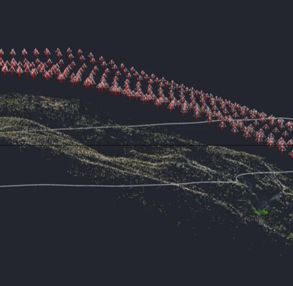
Photogrammetry And LiDAR Data
- Photogrammetry: The process of using photographs to measure distances between objects and create maps or 3D models.
- LiDAR (Light Detection and Ranging): A remote sensing method that uses laser light to measure distances and generate precise 3D models of the landscape.
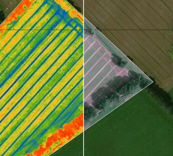
Thermal And Multispectral Imagery
- Thermal Imaging: Captures temperature variations on the Earth’s surface, useful for detecting heat loss in buildings, irrigation issues in agriculture, and environmental monitoring.
- Multispectral Imaging: Captures data across multiple wavelengths, providing insights into vegetation health, water quality, and other environmental factors.
Additional Support Tasks Frequently Turned To Drones Include
- Site Monitoring: view the progress of your project as often as needed with updated aerial imagery. Give decision makers the tools to address problems quickly and check progress is following the schedule.
- Volumetric Measurements: Typically volumetrics require a survey team which can take weeks or months to complete, this leaves room for site interpretation and subjectivity by the survey team. This opens the door for errors such as inaccurate measurements and out of date results. Drones eliminate these errors by offering a fast and efficient way of collecting geospatial data to measure volumes.
- Inspections: Drone inspections are safer, faster, and more detailed than manual inspections. High detailed aerial imagery is collected across an entire site or building and is quickly made available to decision makers.
Legal Disclaimer:
Sierra Drone Concepts provides high-quality land surveying and mapping services, it is important to note that while we have experience in land surveying, we are not State Licensed Surveyors. Our services are intended to extend and supplement survey products, to offer accurate and detailed aerial imagery and mapping for various applications that go hand in hand with land surveying.
For official and legally binding survey records and documents, we collaborate closely with a State licensed Professional Land Surveyor (PLS) who can review, approve, and stamp documents as required. This partnership ensures that all our deliverables meet industry standards and regulatory requirements.
By engaging our services, you acknowledge and agree that any official surveying work requiring a PLS approval will be performed in conjunction with our licensed surveyor partner.